|
The Sardinian-Corsican dolmen structures appear:
-
facilities geared
to specific
astronomical events;
-
religious shrines
of the Prehistoric
era;
-
structures
arranged
along a path
that passes through
the Strait of Bonifacio, thus constituting a
pilgrimage route , like the
medieval Via
Francigena
or
Camino de Santiago de
Compostela;
-
family
burial
of the dominant clan.
Inside the route, some locations may have a very special religious significance,
such as
Luras (four
structures), the area
around
Buddusò
(eleven),
around Berchidda (thirteen) and the
Corsican site
Sartene-Filitosa.
NORTHERN SARDINIA
DOLMEN ROAD
The route starts from Macomer (NU),
a town in the central-northern Sardinia, which can be reached from Cagliari,
taking SS131/Cagliari-Sassari (Carlo Felice) until km 132, exit Borore /
Macomer, and follow signs for 7 miles. Even coming from Sassari, take SS 131
towards Cagliari, until exit Bosa / Macomer, about 62 km. From Olbia, however,
take SS 131 DCN towards Nuoro and Sassari and follow it for about 102 miles, to
the exit Macomer, hence SS 129 for about 36 km and SS 129 bis for other about 3.5,
and follow the directions. Having reached the town, we head to the interesting
archaeological site of Tamuli, which is located about 6 km on the road Macomer
- Santulussurgiu.
|
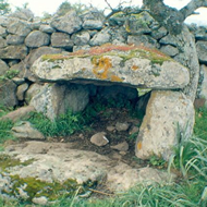
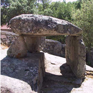
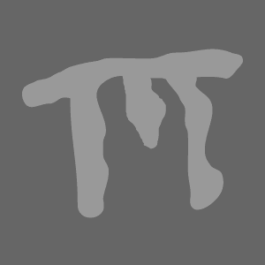
Dolmen Su Edrosu
Source
Betili at Macomer
Source
|
|
A.
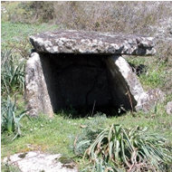
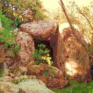
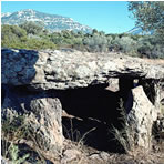
DOLMEN SU EDROSU
AND THE ARCHAEOLOGICAL AREA OF TAMULI (MACOMER)
Dolmen Su Edrosu is the oldest structure in the
archaeological complex and, initially, it was mistaken for a
Giant tomb in poor condition. The burial (length 8 m) is
oriented SE; it holds the burial chamber (length 2.20 m, width
1.75 m), barely legible on the bottom; it is flanked by
two blocks of trachyte, with vertical rows and the header plate
(length 1.35 m, width 1.05, height 0.41).
The rest of the archaeological complex of Tamuli is dated
Nuraghic Age (Bronze Age) as it includes two Giant tombs, one dolmen
and a nuragic village. It was built later than the dolmen age.
The first Giants Tomb has an elongated body and apse, including
a burial chamber and a large semicircular frontal exedra. The body
of the tomb is oriented SE (length 14.40 m, width 7.32 m / 7.10); the
semicircular exedra (14.60 m rope; arrow 7.10 m) has a seat around
the perimeter, formed by 27 blocks, 14 in the left wing and 13 in the
right one. At the center of the exedra, the entrance to the burial
chamber is given by a trapezoidal perforated plate door over a raised threshold. The interest of this megalithic burial is
given by the fact that, on its south side, they are arranged six
(astronomically?) aligned three rocks worked in a conical
shape, named "betili". Each the three largest (height 1.24 m / 1.40)
ones show two
mammillary drafts, and they have been identified as female gender. The
other three, smooth, masculine ones. Next to the cult of dead, then,
the prehistoric Sardinians - probably - also practiced fertility
rites related to male and female gender. The second Giant Tomb, also
willing to S / E, is currently invaded by the collapse and the
earth, but it is possible to identify the profile of its body and
apsidal exedra. The body tomb (length 11.40 m) encloses the
funeral hall (length 8.20 m, width 0.85 m) and retains the entry
threshold (length 1.20 m, width 1.54 m), raised by 0.10 m from the
plane floor and a slab on the south wall. Hemicycle exedra (width
14.50 m) are some flat and polished stones that were part of the
inside floor of the burial chamber.
At short distance from the Giant tombs, on a rocky outcrop, it stands
one nuraghe, complex typed, which
consists in a tower and a bastion bilobed built. At short
distance from nuraghe it extends the nuragic village, and nearby it was
reported a nuragic source.
Guided Tours
Phone:
0785 790800/856 (library), 0785 746034; 3403285316
Hours:
summer: 9,00-13,00 e 15,00-19,00;
iwinter 10,00-13,00 (from thursday to sunday)
Ticket:
€ 2 (adults), € 1 (reduced).
Start from Macomer, and after 3.5 km path for the SS 129 bis, resumes SS 131 in direction Sassari. After 30 kilometers, about, exit at Mores-Ozieri-Olbia, along
SS 128
bis
across about
five
miles, than you can reach Mores.
|
|
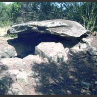
Dolmen Sa Coveccada
Source
|
|
B.
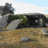
DOLMEN SA COVECCADA (MORES)
At Mores, take Highway 128
direction Ozieri to bend almost immediately
right into
provincial
Bono, after about three
miles,
cross
Rio
Mannu: immediately after
the bridge
turn right
and
take a dirt
road across
700 meters,
until you
see
on the left the iron gate that leads into a farm. Leave the car and go
through the gate,
climb for about 350 meters to the fold, and from there you can go down a path
that winds to the left under a rock bridge after
7-800 meters, at a bend, suddenly it appears Dolmen Sa Coveccada, isolated in the plain.
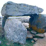
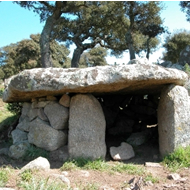
Sa
Coveccada
is the
most
impressive example of dolmen in
Sardinia and is also exceptional in the Mediterranean: 2.70 meters high, it consists of three
large
sheets, about 5 feet long, supporting
a
fourth,
table
cover,
scale
unmatched
in
Sardinia: 6 feet long, 3
wide,
60 cm
thick,
and weighs
about 27
tons.
The dating
of the
structure is generally referred about 2500 BC (beginning of the Copper Age).
The
monumental
rocks of
gray - pink
trachyte, are accurately machined
and
hammered.
At the left
of the
closing
plate
there is a small niche, whose
function has not emerged with certainty. Another element of great interest it is
the circular
opening,
at ground
level,
in the
front
screen. This
characteristic makes
Sa Coveccada as a unique case in the Sardinian dolmens and it clearly foreshadows the similar front openings of the later
Giant Tombs (Bronze Age).
Scholars Edoardo Proverbio and Pino Calledda in 1995, have also
noted
dolmen Sa Coveccada, and measured its azimuth 123.8°;
it substantially is the winter solstice sunrise azimuth
(See: Pino Calledda and Edoardo Proverbio, Statistical analysis of
the guidelines of megalithic tombs in Sardinia, in: Italian
Journal of archaeoastronomy II, Edizioni Quasar, Rome, 2004, p.
45 and subs.)
This astronomical solstice target, however, appears isolated, in a
context where the star target seems more applicable to the alignment
of Sardinian and European dolmens. As the overall series of the European and Mediterranean megalithic structures show that
the star target is earlier than the lunar and solar one; so it is
reasonable to assume, for Dolmen Sa Coveccada, a more recent date
than the commonly assumed one by scholars (2,500 BC). This hypothesis - in
our opinion - would be supported by the gigantism of the structure
and through the circular opening on the front screen, similar to
the later Giant Tombs. Our hypothesis, therefore,
would place this dolmen on the Early Bronze Age (about 1800
BC). Near Sa Coveccada it is a standing stone (an
elongated vertically stone standing in the ground) broken into two sections,
relating to an astronomical alignment, no longer traceable.
Guided Tours: Dolmen, piccola società cooperativa a
r.l. Phone 079706551
Back in Mores, take SS 128 in the direction of Ozieri,
through one of the most fascinating nature trails of northern
Sardinia, about 17 km.
|
|
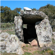
Dolmen Montju Corona
Source
Dolmen
(Nughedu San Nicolò)
Source
Dolmen Monte Maone
Source
|
|
C.
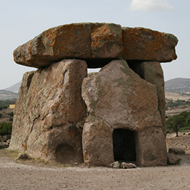
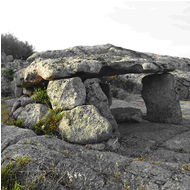
DOLMEN DI MONTJU CORONA (OZIERI)
At Ozieri is located Dolmen Montju Corona (see photo). This is a
dolmen with a rectangular plan with a 9.80 meters long tunnel. Edoardo
Proverbio and Pino Calledda have measured its orientation identifying an
azimuth of 64.6° and a declination of 18.91°, which could match a lunar
astronomical target (the lower Southern lunistice).
D.
DOLMEN SU PEDRIGHINOSU
(NUGHEDU SAN NICOLÒ)
Starting from Ozieri, take a short detour to Nughedu St.
Nicholas, located a few kilometers along SP 36. At Punta Sordanu
there are three dolmens, called Su Pedrighinosu I, II and III.
is on a grid; during the centuries the dolmen in the picture has
been backed by a drywall fence. About 3 meters in front of it,
it lies a menhir high 1.20 m. Su Pedrighinosu I, has this
astronomical orientation, as measured by Proverbio and Calledda:
azimuth 127.4°; declination - 26.83°; Su Pedrighinosu II:
azimuth 358.70° and declination 48.92°; Su Pedrighinosu III,
azimuth 19.30° and declination 45.34°. Interesting it is the
astronomical orientation of the second of three dolmens,
corresponding to the North Star
E.
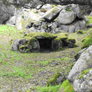
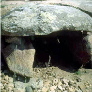
DOLMEN DI MONTE MAONE (BENETUTTI)
Reaching Benetutti; follow the path that runs along two sides of
the cemetery. Approximatively 2 km on the left there is the
bottom entrance gate of the ground called Maone. After passing a steep hill toward
south-east, go to a farmhouse. The dolmen is located on
the right, behind the dry stone wall.
This monument is particularly interesting because it is a hybrid
between two different systems of burial. You can define a mixed
dolmen. It consists of part of a cave carved into a natural rock,
like a Domus de Janas, covered by a single slab and completed on the sides and
raised in masonry. The monument (length
3.5 m, width 1.3 m) includes a little trapezoidal leaf
(width 0.65/1.20 m.; length 0.87 m.) oriented South, and a
rectangular room (width 1.30 m.; length 1.75 m.; height 1.90 m) now
filled with earth.
At Benetutti take again SS128 towards Bitti and then take SS 389dir turning left
direction Buddusò.
|
|
Dolmen Su Laccu
Source
Dolmen Orunita
Source
Dolmen Elcomis
Source
Dolmen Sos Monimentos
Source
|
|
F.
DOLMEN SU LACCU and SOS MONIMENTOS (BUDDUSÒ)
About five miles before this town, ie immediately before km n. 44, on the left,
take a dirty road through a cork; after a couple of miles, there
is the locality called
Su Laccu, where is located the dolmen same name.
The monument consists of two slabs laterally fixed, that
exploit the parent rock outcropping in the support plane; the
left one it measures 0.90 m. height and 2.45 m. length; the
right one it measures 0.95 x 1.55 m. Due to the difference in height, slab roof
is slightly tilted and measure 2.30 m. length and 1.10
m. wide.
The target star, discovered by Proverbio and Calledda, it
corresponds to an azimuth 172.5°, with declination - 45.37°, in the direction occupied by
Alpha Muscae in 2400 BC or by Alpha Crucis in 1300 BC. We
may give credit to the first hypothesis of
orientation, which would date the structure of the full Copper Age. There is a guided tour in a route that includes the
Domus de Janas, the Giant Tomb and the Museum of
Contemporary Art.
Hours:
9,00-13,00 e 15,00-19,00 monday-friday (groupes reservation
saturday and sunday too)
Ticket:
€ 3
(full), € 1,50 (reduction)
Continuing to the public road, after about a mile, you arrive in
the village Monimentos. Clearly visible on the ground level, at
a distance of about 30 meters, on a hill to the left of the dirt
road, there is a second dolmen, called Sos Monimentos.
It is an area of dense attendance of prehistoric (probable
remains of a necropolis, one menhir, other structures of
uncertain definition) in a particularly attractive and
well preserved environment. Sos Monimentos is a circular dolmen,
with a chamber measuring m. 1.80 x 1.00, surrounded by a granite stone
wall.
At the entrance of the structure there are two rectangular shape
plates about m. 0.60 high. On these plates rests an
approximately circular covering, m. 2.50 x 2.25 wide. It has not
been detected its possible astronomical orientation.
At about seventy meters you can see the source of the River
Tirso.
Retrace the dirt road up to resume the local SS 389. Not
far away, and exactly at km. 45.500 you should take a side road that
leads to the paved edge of the forest compendium of Orunita.
Within the grove is located Dolmen same name, whose target
(azimuth 285°; declination 13.71°) is facing Beta Andromeda
in 2650 BC; 'therefore it's older than previous Su
Laccu, and we can date it to the last centuries of the Neolithic
Age.
It should be recalled, near Buddusò, the site of Elcomis, where
there is another dolmen (self-titled), consisting of some stones
stuck in the ground, and supporting a slab 3 x 2 m., surrounded by
an elliptical fence stone. Dolmen Elcomis seems built
about three centuries later Su Laccu, as its orientation
(azimuth 161.9°; declination - 46.75°) point toward star
Alpha Muscae, too, but in 2100 BC. Both dolmen, simplest built than Sa
Coveccada, are probably earlier than it, but with the same
astronomical cult.
We follow now SS 389 toward Buddusò, then SS 389 until Pattada,
than the road Pattada north direction, along the long course of
Oschiri Rio Mannu until SS 199 near Oschiri: on the right and
after a few kilometers, turn right again at Berchidda junction .
|
|
Dolmen Santa Caterina
(Abialzos, Berchidda)
Source
Dolmen Sant'Andrea
(Abialzos, Berchidda)
Source
Dolmen Monte Acuto
Source
|
|
G.
DOLMEN at ABIALZOS and MONTE ACUTO (BERCHIDDA)
Not far away Abialzos, near the rural churches of
Santa Caterina and Sant'Andrea (well marked by signs), there are
two dolmens. In particular, near the church of Santa Caterina,
we can observe a simple dolmen surrounded by large granite
boulders. The right wall is formed by two irregular boulders
fixture in the ground as a knife. The covering slab has a
pentagonal shape and it is resting on all three sides.
By the church of St. Andrea there is an archaeological site
where is located a second dolmen which is an uncovered tomb built by
only three blocks, including the rectangular form cover plate;
nearby there are some evident menhirs, too. Edoardo Proverbio and
Pino Calledda have measured the orientation identifying an azimuth
242.5° and a declination -21.73°, which may correspond to the
star Sirius in 2700 BC
At Abialzos too, there is a third dolmen (Dolmen Abialzos);
Proverbio and Calledda have defined it "allée couverte" (see photo). The two
researchers have measured its orientation detecting an azimuth
53.8° and a declination 24.41°, corresponding, with a good
approximation, at sunrise, dawn of the summer solstice.
Back to Berchidda village, continue along the road that
leads to lake Coghinas and after about three miles, turn right
to Monte Acuto. At the end of the road, leave the car and go up to
walk in the direction of the peak, about 200 meters there is the
dolmen of Monte Acuto, recently discovered and fully excavated. Its
rather rare characteristic concerns that its plates are
supported by the natural rock, using it for static purposes.
The monument is
part of a vast archaeological area which occupies the slopes of the
mountain, consisting of numerous rock shelters and traces of other
structures still under investigation. From the summit of the
mountain, at which they stand the ruins of an ancient Judicial
castle,
you can enjoy a magnificent view both to the north towards the
nearby massif Limbara both in the south to the lake Coghinas and the
plain of Ozieri.
Return to the junction to Berchidda and turn right into the
lake Coghinas, reaching a few kilometers west state highway 392:
then turn right to Tempio; there take SS 127 towards
Calangianus, then turn left to Luras. |
|
Dolmen Ladas
Source:
F.Bardanzellu
Dolmen Ciuledda
Source:
F.Bardanzellu
Dolmen Alzoledda
Source
Dolmen Bilella
Source
|
|
H.
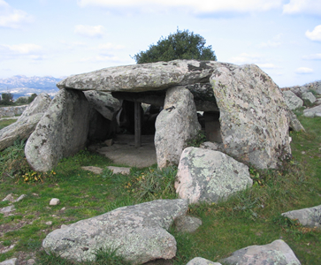
DOLMEN ALZOLEDDHA, BILELLA, CIULEDDHA and LADAS (LURAS)
Luras, Province of Olbia/ Tempio, is the best represented town
in the island. with four examples of dolmens (Ladas, Alzoledda, Ciuledda and
Billella) out of 215 identified to date (Cicilioni, 2009).
Dolmen
Alzoleddha and Bilella are located near the sports field, Ciuleddha and Ladas, along the road towards
Luogosanto. Follow, however, the signs.
The inhabitants of Luras used to call these dolmens: "Sepulturas de
zigantes or de paladinos"; they was constructed for collective
burials and as a place dedicated to the worship, since fourth millennium B.C. These
monuments, all dated in the late Neolithic period (3500 - 2700
BC), are comparable to the specimens of Corsica,
above all, Menorca and Basque, Catalan and French regions.
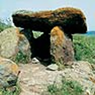
DOLMEN LADAS
Dolmen Ladas is approximately dated 3000 BC, as some fragments
of pottery with no special decorations
discovered belove it; it is the most imposing prehistoric structure
in Luras, for its grandeur and scope. According to some
scholars, however, the largest dolmens of Luras would not be dated
at the Neolithic, but at the Ancient Bronze Age (1800 - 1600 BC), on the
threshold of Nuraghic period. It consists of a large covered gallery
which measures 6 meters length and 2.20 m. height, covered by
two large slabs and equipped with an apse rear. The cell is
divided in two parts by a transverse slab. The capstone rear -
the second largest example in the Mediterranean - is enormous:
it has an area of about 15 square meters and its sides measure m. 4.80 X 3.42, with a thickness of 45 cm.
It was
apparently machined and polished at the bottom. The input is one
meter high, and m. 2.30
wide. The walls are formed by orthostatic
(upright) and fairly regular plates, flanked by some flat rocks arranged in an
oblique position.
Astronomical
Target
Azimuth: 173°00
Latitude: 40°94
Declination:
-44.59°
Source: Proverbio & Calledda,
Rivista Italiana di archeoastronomia, Rome 2004.
As mentioned above, based on the discovery of some fragments of
pottery with no special decorations, Dolmen Ladas has been
approximately dated on 3000 BC, also taking into account its
most advanced construction technique, compared to the other
examples in Luras, dating back to 3500 BC. These
characteristics have led some scholars to date it on the ancient
Bronze Age (1800 - 1600 BC). Its astronomical target is
according
to most of Corsican dolmen structures, oriented
towards Centaurus/Crux/Musca system. In particular, the
entrance of dolmen Ladas is oriented towards Alpha
Muscae (the brightest star in the constellation of Musca, the
lower unit of the whole system above) in 2800 BC. This confirms
its assignment at the time of the final Ozieri culture (Recent
Neolithic). The bottom of Centaurus/Crux /Musca system, that is the constellations of Crux (South) and
Musca, are no longer visible in the northern hemisphere since
three thousand years. To match it to a most recently stellar
target, we should reach the Medium Bronze, and, in particular
about 1400 BC when the input of the dolmen was oriented towards
Alpha Crucis. This timing, anyway, it seems too recent for the supporters of
the late dating.
DOLMEN CIULEDDA
Dolmen Ciuleddha plant has a semicircular shape. It was
builded in a construction technique
similar to Ladas, but in a
reduced scale. It has a semicircular burial chamber and the
entrance facing south-east; the top plate measuring m.3.42 X
2.35; the total height of the monument is about 90 cm. In dolmen
Ciuledda, as in Ladas, there were found some fragments of pottery, without
special decorations, which allow approximate dated on the third
millennium BC.
Astronomical
Target
Azimuth: 128°90’
Latitude: 40°94’
Declination:
-26.41°
Source: Proverbio, Calledda,
Rivista Italiana di archeoastronomia, Roma 2004.
Dolmen Ciuledda, based on the discovery of some fragments of
pottery with no special decorations, was approximately dated to
the third millennium BC His astronomical target is more accurate
and can be reported to the star Rigel in 3100 BC, the previous
millennium, that is, to that of the general dating given by
archaeologists. Ciuledda, therefore, has been produced at
least three centuries before Ladas, as shown by the
technique less refined than the more majestic dolmens in Luras.
Rigel is the brightest star in the constellation of Orion and,
in prehistoric times it played a particularly dense meaning of
religious references to the megalithic people.
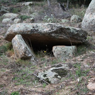
DOLMEN ALZOLEDDA
The small Dolmen Alzoledda is a simple type gravestone,
rectangularly shaped with the entrance facing east and a
trapezoidal room. It's generally referred to the Ozieri Civilization
(3500-2700 BC.). The side walls are both composed of an
orthostatic plate
surmounted by some stones of reinforcement, while
the bottom wall is formed by a single orthostatic quadrangular
plate that protrudes from the walls almost half a meter. It is 2.65 m
length, 2.20 m width and 1.65 m. height.
Astronomical Target
Azimuth: 150°40’
Latitude: 40°94’
Declination:
-38.09°
Source: Proverbio, Calledda, Rivista Italiana di archeoastronomia,
Roma 2004.
Dolmen Alzoledda is generically referring to the civilization of
Ozieri (3500-2700 BC.). At that time, in direction of the
entrance of the structure, particularly around 2825 BC,
it stood Alpha Crucis, which is the brightest star in the Southern
Cross (which, as mentioned, is no longer visible in the northern
hemisphere from about three thousand years). Four hundred years
later, in the same direction, stood Rigil Kent, which is the
brightest star in the constellation Centaurus, but this date it
seems too recent.
DOLMEN
BILELLA
Dolmen Bilella is generically referred to Ozieri
Civilization (3500-2700 BC.), too. It has a rectangular plan and
an entrance facing north-east.
The right wall is constituted by an
orthostatic rectangular
slab; the left one by two partially processed boulders, resting on the natural rock. One of these
rocks has been artificially adapted on the insertion of the
coverage slab, flattened in its upper left natural surface. For this feature
it is an unusual and almost
unparalleled dolmen; it is 2.50 m. length, 1.40 m. width and
0.80 m. height.
Target
astronomico
Azimuth: 24.30°
Latitude: 40.94°
Declination: 49.01°
Source: Proverbio, Calledda, Rivista
Italiana di archeoastronomia, Roma 2004
Dolmen Bilella has an unknown astronomical target, facing north-northwest.
It is opposite to almost 85% of dolmens examined by Proverbio and
Calledda, which are oriented towards south and southeast.
This
feature would suggest that, rather than toward the rising of a
star, or a stellar group, it is facing the sunset. The data we have
about the position of the constellations in prehistoric times,
do not allow us, however, to give an objective response. His
property may also be facing some additional natural or
artificial object, but this hypothesis remains to be demonstrated.
|
|
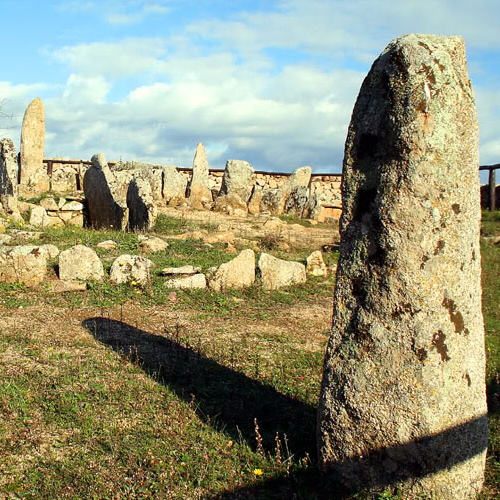
Li Muri circles and menhir
Source
|
|
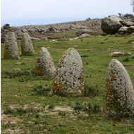
I.
MEGALITHIC CIRCLES at LI MURI (ARZACHENA)
To reach the location of Li Muri, near Arzachena, let
Luras taking the road that leads to the junction with SS
133: here turn right in the direction of Palau and reach
Bassacutena, after
passing the junction for Luogosanto; here
turn to Arzachena. Along this road, after about seven
kilometers, turn off right to the site of Li
Muri.
This particular prehistoric
burial type concentration in the sites of Arzachena and a few other contiguous has led
some archaeologists to identify a specific "Culture of
Arzachena" that characterizes the Copper Age in northern
Sardinia. Near Arzachena, in fact, we have been found fifty circles
tombs, which have a diameter ranging from 5 to 8.7 m. 75%
of them are oriented to the south. The necropolis of Li Muri is
the most interesting example of that type of funerary
structures in the shape of cassette without opening formed by
slabs of stone stuck in the ground. The necropolis consists of
five "dolmen cysts" each of which is surrounded by a "ring" of
large stones arranged in concentric circles, which should
safeguard by leaching the mound that covered. The circles
outermost are contiguous to each other.
Between the tombs there are three small rectangular
enclosures and parts of tombstones interpreted as elements of the funeral ritual.
Outside of the complex stands one isolated menhir with three
concavities. In July 2000, the writer has identified other three
menhirs within the complex; two are both aligned with a side
plate of one of the graves in the direction south, and the other
side plate of the same tomb is aligned toward a third menhir, still
heading south. The most exterior of the first two menhir is also
aligned with the lateral slabs of two other tombs in the west.
Proverbio and Calledda have also calculated the astronomical orientation
of the four more conserved dolmen cysts, but these
data do not allow us to identify a particular target.
Structure |
Azimuth |
Declination |
Target |
Cyst I |
93.3 |
0°21 |
? |
Cyst II |
181.1 |
-49°49 |
? |
Cyst III |
166.6 |
-47°57 |
? |
Cyst IV |
201.8 |
-44°01 |
? |
Despite the narrowness of their proportions, the "circles" of
Arzachena found evidence in the Anglo-Saxon circular mounds of
the Neolithic age (see Windmill Hill, UK) and may have similar
stellar orientation. Within some graves they were found some funerary
objects, now exhibited at the Museum Sanna in Sassari and
at the Archaeological Museum in Cagliari; worth mentioning, among
others, a cup of steatite with handles in the spool (like
"Diana"), some necklaces vague shell and some apples hollow
spheroids, still in steatite, originally mounted on sticks and
perhaps used as weapons, or perhaps as insignia of command.
There is a
service of guided tours. From here you can reach in a few
minutes Arzachena and then Palau, for shipment to Porto Vecchio,
and continue the path of the dolmen of Southern Corsica.
Who has a car, however, will be forced to head to Santa Teresa
di Gallura and from there, take the ferry to Bonifacio,
therefore, must go to Porto Vecchio.
|
>
To be
continued :
SOUTHERN CORSICA
DOLMEN ROAD
|
|
|